Welcome to the Oki Islands UNESCO Global Geopark
UNESCO Global Geoparks are unified areas having a unique geological heritage of international significance. Operating under a holistic framework of protection, education, and sustainable development, geopark initiatives extend beyond just the geohistory: They encompass the entire region, including its ecosystems and traditions. After being designated as a Global Geopark in 2013, the Oki Islands subsequently became a UNESCO Global Geopark after the Geoparks program came under the UNESCO umbrella.
Lying about 60 kilometers off the coast of Shimane Prefecture in the Sea of Japan, the Oki Islands group consists of four inhabited islands and many more uninhabited islets. The geopark includes both the islands and the surrounding marine environment. The four permanently inhabited islands are split into two groups: Dōgo Island and the Dōzen Islands (Nishinoshima Island, Nakanoshima Island and Chiburijima Island). Each of the four islands has one municipality, and it is helpful to consider them as a set when learning the geography of the islands and planning your visit.
A Brief Overview
Dōgo Island (Okinoshima Town, population 13,600): With towering rocky cliffs and majestic Japanese cedar tree forests, time-honored sacred traditions live on in the largest of the Oki Islands. Beginning with the obsidian This will open in a new tab. that was mined on Dōgo Island and transported to various places, diverse people and cultures have come together here since ancient times.
The Dōzen Islands:
Nishinoshima Island (Nishinoshima Town, population 2,500): Built on the fishing industry which flourished in the Sea of Japan, this island is home to Takuhi Shrine, from where the deity of maritime safety has kept watch for centuries. Nishinoshima also has some of Japan’s best coastal scenery, including the stunning Kuniga Coast.
Nakanoshima Island (Ama Town, population 2,300): Emperor Go-Toba, one of the most revered figures in Oki history, was welcomed by residents following his exile from the mainland in the thirteenth century. The people of Nakanoshima continue to be open to new possibilities amidst a thriving culture of hospitality and innovation.
Chiburijima Island (Chibu Village, population 600): Chiburijima Island is the smallest and southernmost of the four inhabited islands, lying closest to the Japanese mainland. Natural beauty abounds on this serene island, where cows roam the hillside pastures atop Mt. Akahage and panoramic sea vistas await at every turn.
Where the Earth Breathes
The islands of Japan, including Oki, were once part of the supercontinent Pangea, which slowly broke apart, eventually becoming other smaller continents. The Japanese archipelago was formed after splitting from the Eurasian continent around 26 million years ago.
The Oki Islands subsequently emerged from the bottom of the sea between the Japanese archipelago and the continent, after a gradual uplift of tectonic plates and a long period of volcanic activity about six million years ago.
The Oki Islands and their geological heritage serve as a record of the processes that resulted in the formation of the Japanese archipelago. Coastal erosion of rock faces over time has created the beautiful coastal scenery, cliffs and rock formations we can see today.
Discover more about the geohistory and ecosystems of the islands from the comprehensive exhibits at the Oki Islands Geopark Museum, located next to the ferry terminal in Okinoshima Town. The Geo Lounge on the first floor of Hotel Entô (Ama Town) has an exhibition room with information on the geology and culture of the three Dōzen Islands, as well as beautiful sea views from the relaxation area.
Natural Works of Art
Here are just some of the natural wonders of the Oki Islands, featuring breathtaking vistas and geological formations carved out over the millenniums. Be sure to bring your camera or smartphone because you will want to capture every moment.
Dōgo Island (Okinoshima Town)
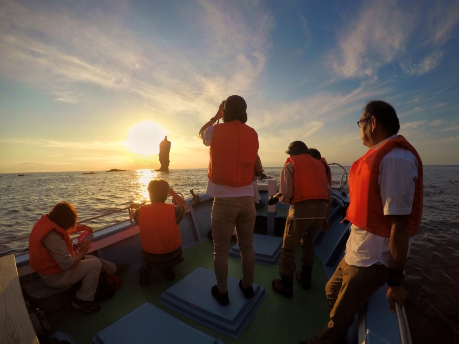
One of the most iconic sites in the Oki Islands is Rosoku-jima (Candle Island), a 20-meter-tall sea stack which looks like a huge candle standing in the sea. Sea stacks are islands of rock that have become separated from the main shoreline by erosion, and worn down over thousands of years by waves and wind. Rosoku-jima itself is impressive but the real magic happens at just before dusk, when the setting sun aligns with the rock as if “lighting” the candle. This magnificent sight can only be seen from the Rosoku-jima Sightseeing Boat, as your skillful captain maneuvers the vessel to create picture-perfect opportunities.
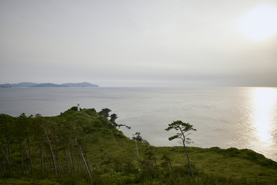
The layers of rock you can see along Jōdogaura Coast were formed by volcanic eruptions around 26 million years ago. “Jōdo” means heavenly, and after visiting this picturesque coastline you will understand why it earned this name. Nagu-saki Cape offers stunning views of the sea and of the Dōzen Islands in the distance. It is particularly popular at sunset. Shirashima Lookout is located on Dōgo Island’s most northern point and is known for the contrasting colors of the blue sea, white cliffs and green pine trees. A walking trail leads down to the coast, and it is recommended to explore the area as part of a guided tour to make the most of the experience.
Nishinoshima Island (Nishinoshima Town)
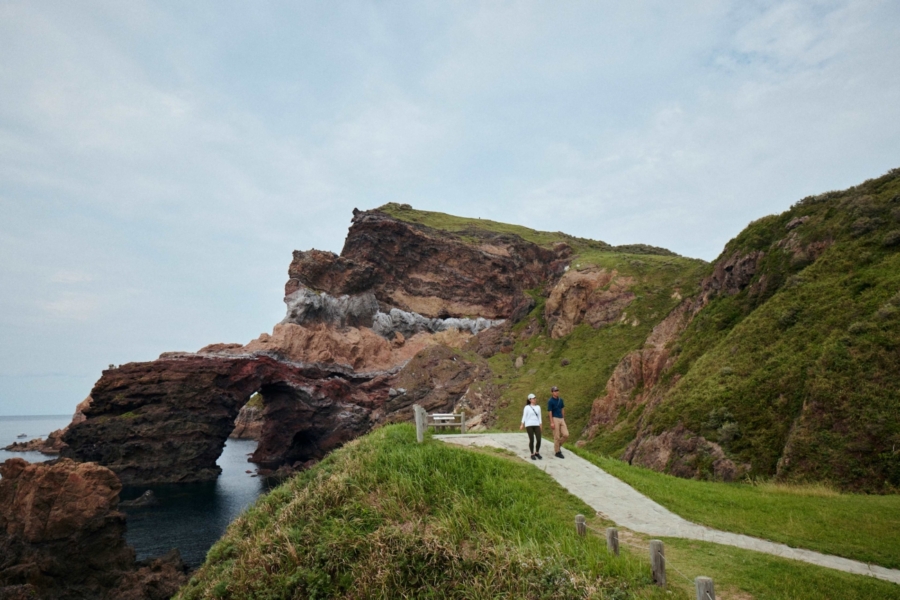
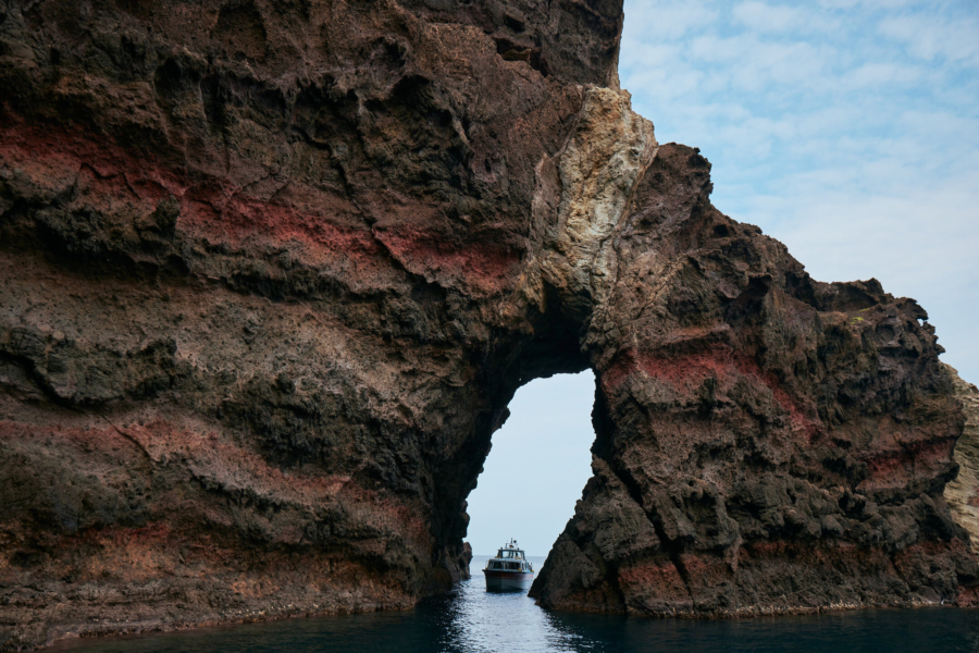
Kuniga Coast stretches for 13 kilometers and features a variety of magnificent rock formations. Among them is the 257-meter-high Matengai Cliff, which affords fine views of both Nishinoshima Island and neighboring Chiburijima Island. The layers of alternating colors in the cliff show the repetitive volcanic eruptions that created the land. Another highlight on the coast is Tsūtenkyō Arch, which was formed from the repeated action of the waves upon the rock. The arch was once the entrance to a sea cave, which crumbled away due to landslides and erosion, leaving the opening you can see today. You can follow a hiking trail from the Matengai Cliff down to the Tsūtenkyō Arch. The hiking trails around Kuniga Coast provide opportunities for birdwatching and for viewing the various flowers that grow here from spring to autumn. You may also see grazing cows and horses along the way.
Enjoy a trip out on the Kuniga Sightseeing Boat to get a different perspective on the rock formations. Sea conditions permitting, the experienced captain takes passengers along the only canal on the islands and through sea caves, including one that is 250 meters long. See more beautiful views of the Kuniga landscape from the Akao Lookout, which allows you to take in the entire coast, including the top of the Matengai Cliff and the Tsūtenkyō Arch.
Nakanoshima Island (Ama Town)
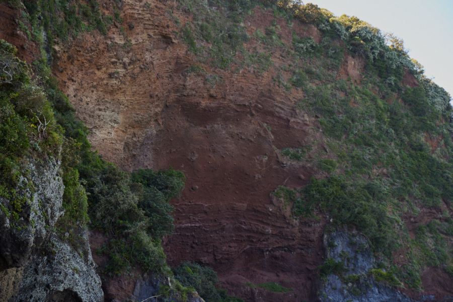
One of the most popular attractions on the island is the picturesque Akiya Coast, which is connected with an interesting legend: The gods Uzuka-no-mikoto and Hinamachihime-no-mikoto fell in love and had a daughter, Yanai-hime. It is said that her birth took place along this coast, and the region has come to be associated with a happy marriage and healthy children. The bright red rock you see is called “scoria” and it was formed by accumulated lava that sprayed from a volcano. Fittingly for this romantic location, there is a heart-shaped hole in the rock at the end of the coastal trail here.
Another photogenic spot with a backstory is the Saburō-iwa Rocks. The three rocks that make up the formation are said to be brothers named Tarō (the largest rock), Jirō (middle) and Saburō (smallest). The best way to see them is from the Amanbow, a sightseeing boat with an underwater viewing area that allows you to get an excellent view of the local marine life.
Chiburijima Island (Chibu Village)
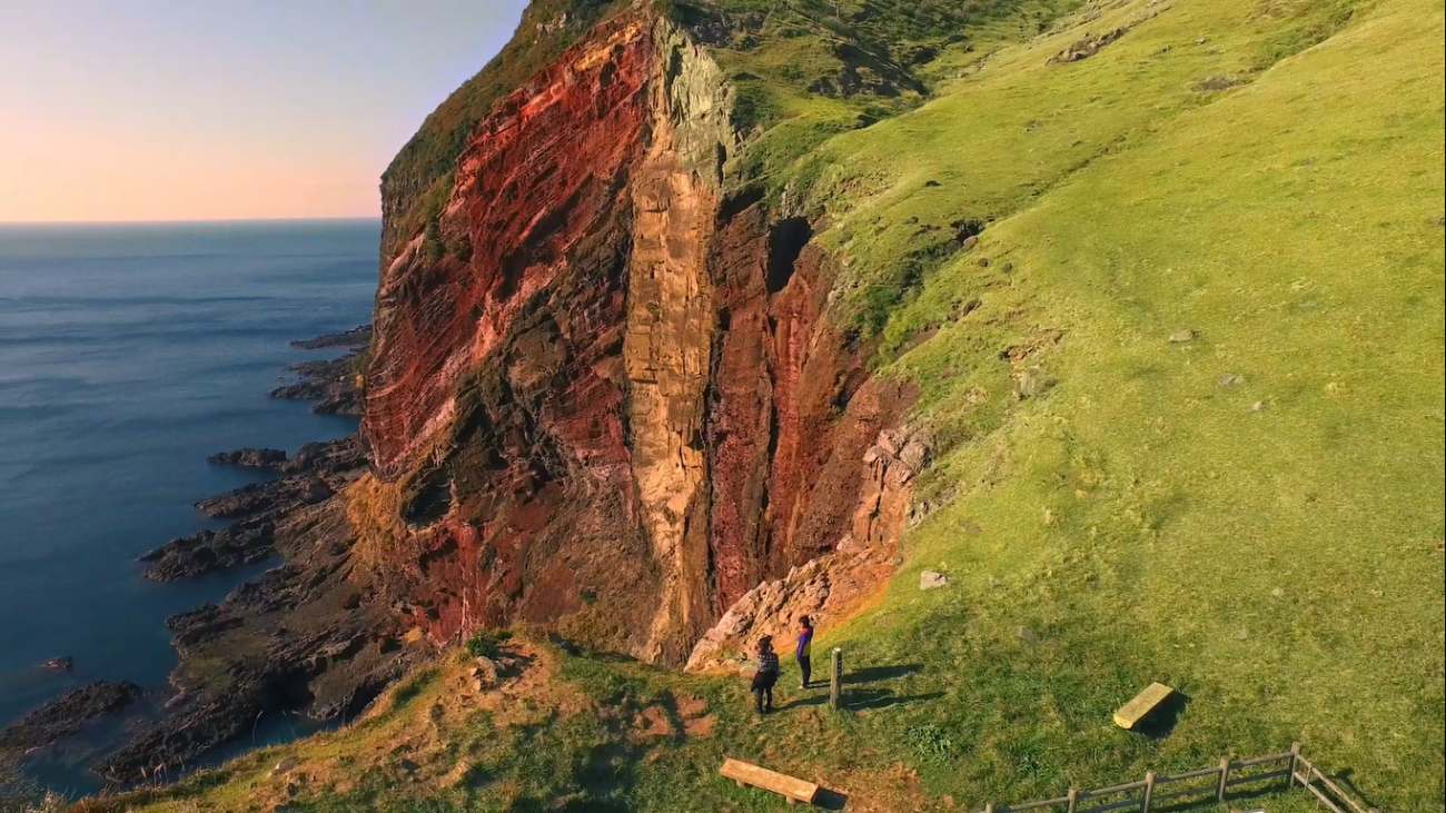
The vivid Sekiheki (Red Cliff) is the cross-section of a small volcano that was once located here. The cliff’s red rocks got their color when iron-rich lava spray from the volcano came into contact with the air, causing it to oxidize. It is easily accessible on foot from the car park, or you can get a closer look at the rocks by taking a trip out on the Sekiheki Sightseeing Boat.
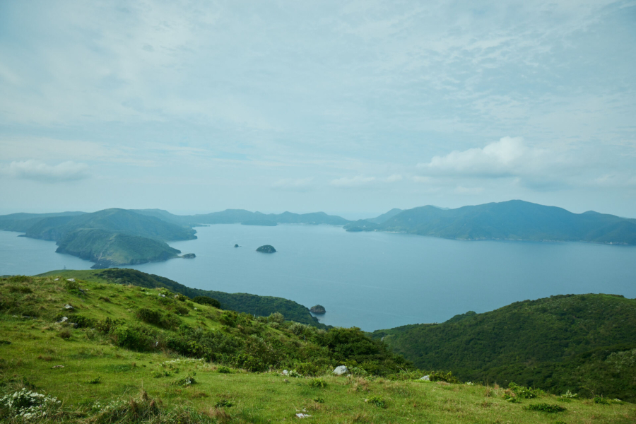
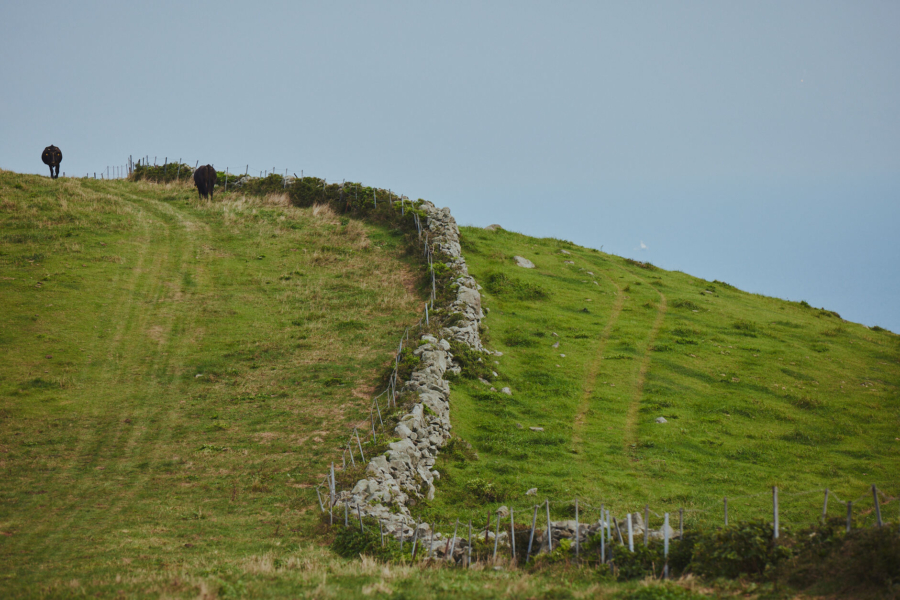
Mt. Akahage is the highest point on Chiburijima at 325 meters. This is the best spot from which to see the three islands of the Dōzen Caldera (three Dōzen islands) in its entirety. Moreover, you will have a 360-degree-view of all four Oki Islands and—weather permitting—as far away as the mainland of Japan. Cows graze on the pasture around the mountain, seemingly unbothered by the height. Mt. Akahage is also an ideal place to see remains of stone walls from makihata farming. Makihata was an innovative method of rotating crops and stock, with fields divided into four sections and marked by stone walls. This method was successfully employed for centuries in the islands, and was in use on Chiburijima until the early 1970s.
Yours to Enjoy and Protect
There are many ways to immerse yourself in the nature and landscapes of the Oki Islands. Multiple hiking trails skirt the coast, or lead through forested mountain slopes. Some of these are self-guided while others are best experienced with a local guide. Cycling, sea kayaking and fishing tours are also available. Whether you are seeking an active outdoor adventure or peaceful solitude at one with nature, it is yours to discover here in the Oki Islands.
Please help to protect the geological and natural heritage of the Oki Islands during your visit, particularly in the following designated Special Protection Zones: Kuniga Coast (Nishinoshima Island), the area near Sekiheki Red Cliff (Chiburijima Island), Mt. Daimanji, Shirashima Coast and Jōdogaura Coast (Okinoshima Town, Dōgo Island). Take litter away with you and keep pets on a leash. Don’t disturb or attempt to remove the wildlife, plants or rocks, and don’t wander off the designated hiking trails. For more information on the code of conduct and helpful safety tips for your time in the Oki Islands, please click here.